
 In a groundbreaking development, Dr Rupesh Kumar, a Professor in the Department of Electronics and Communication Engineering, has been awarded a significant project titled “Mapping the Canopy of the Amazon Forest Using an Aerial Drone Platform Coupled with Radar Sensors.” The initiative, funded by the International Peruvian National Research Institute, boasts an impressive outlay of Rs. 1.11 Crores and is set to span over a two-year period.
The project is spearheaded by Principal Investigator Dr Mark Donny Clemente Arenas, an Associate Professor at the National Technological University of South Lima in Peru. This collaboration aims to enhance the understanding of the Amazon’s intricate canopy structure and promote conservation efforts through innovative technology.
In recognition of this notable achievement, SRM University-AP proudly congratulated Dr Kumar and highlighted the significant impact this project could have on environmental research and sustainability. The university’s support underscores its commitment to fostering research initiatives that address global challenges, encouraging faculty members to pursue innovative solutions through collaboration and the application of cutting-edge technology.
This initiative marks a significant milestone in international research collaboration, leveraging technology to address critical environmental challenges in one of the world’s most vital ecosystems.
A Brief Description of the Project
This project facilitates the mapping of the Amazon forest in Peru. An integrated approach of advanced sensors such as LiDAR, Millimeter-Wave Radar, Camera, etc. and UAV will achieve this.
This will help assess the Amazon forest’s health in real time by leveraging the ML/AI approaches.
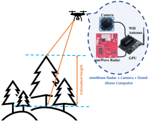
Figure 1: Scheme for height estimation
Explanation of the Research in Layperson’s Terms
The plant/tree generally reflects radio waves and other signals, and this reflection depends on the density of the forest. If a suitable signal processing is applied to the reflected signals, it will provide insight information about the forest profile. Nevertheless, this will help in the quantification of land covered by trees, identifying the location of those trees. Consequently, the tree canopy assessments help in determining the amount and location of impervious cover.
Funding Agency and Amount Sanctioned
National Scientific Research and Advanced Studies Program (PROCIENCIA) of the National Council for Science, Technology and Technological Innovation (CONCYTEC), Peru.
In Spanish: “ Programa Nacional de Investigación Cientifica y Estudios Avanzados (PROCIENCIA), del Consejo Nacional de Ciencia, Tecnología e Innovación
Tecnológica (CONCYTEC), Perú”.
Practical Implementation of the Research or the Social Implications Associated with it
The proposed research work help will help in the assessment of deforestation as well as its impact on climate change and global warming. Not only this, but the research will also contribute to achieving carbon neutrality by 2050!
Collaborations
Universidad Nacional Tecnológica de Lima Sur
Collaborator: Prof. Mark Clement Arenas
Future Research Plans
In future, this work will be extended for infrastructure monitoring. With the boom in real estate, a continuous monitoring system is desired for proper maintenance.